
Any comments, suggestions or just looking for a chat about this subject? Don't hesitate and leave a comment on our improved comment section down below the article!
By Alexander Roberts - University of Leeds
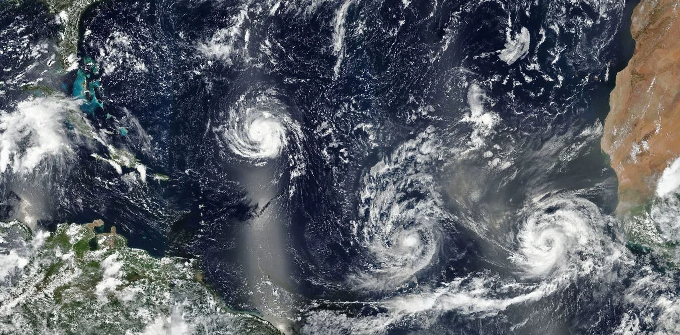
Storms Florence, Isaac and Helene on September 9. = Image Credits: EPA / NASA
Shortly after Hurricane Helene formed off the coast of West Africa on September 7, it did something unusual. Instead of following most hurricanes westward across the Atlantic, Helene turned north towards the UK and Ireland. Now downgraded to an “ex-hurricane”, Storm Helene is nonetheless expected to bring strong winds across much of England and Wales when it hits on September 17.
Something similar happened in October 2017 when ex-Hurricane Ophelia turned north and hit the British Isles, causing three deaths and more than 200,000 homes to lose power.
At the time, Ophelia seemed like a very unusual storm due to the direct course it took across the Atlantic. However, two storms of this type in two years naturally raise the question of whether this is the new normal. As the ocean and atmosphere continue to warm, can people in Britain and Ireland expect more rogue, autumnal hurricanes?
Helene goes rogue.- Image Credit: Master0Garfield / NASA / NHC
Storm origins
Broadly speaking, storms generated in the Atlantic fall into two categories. Normally, the storms responsible for poor autumn and winter weather over the British Isles are mid-latitude cyclones. These storms are largely fuelled by the atmospheric instability where cold and warm air masses meet. Many will be familiar with such features in the form of fronts shown in television forecasts.
In contrast, tropical cyclones, including hurricanes, derive most of their energy from the warm ocean waters over which they form. The change of state from water vapour to cloud droplets releases latent heat (energy) and produces deep convective clouds (thunderstorms). When conditions are favourable, a strong low pressure feature develops and helps to transport more fuel (in the form of moist air) into the storm.
It is not unusual for tropical cyclones to develop into mid-latitude cyclones (this happens several times a year). In the Atlantic, the transition usually occurs when tropical cyclones have tracked west and gradually curved north into the mid-latitude storm track. However, the direct nature of the route taken by Ophelia and now Helene marks them out as unusual.
So, do Ophelia and now Helene suggest a change in Atlantic storm behaviour? To understand this we need to think about how climate change will impact storms both in tropical and temperate regions.
Physical mechanisms
There is now a very clear trend of increasing sea surface temperatures, and it might be expected that warmer seas would lead to more frequent or more powerful tropical cyclones. However, it isn’t yet clear if that is the case for Atlantic hurricanes.
What is likely is that warming seas will enable tropical storms to form further north, potentially meaning more will reach the polar front and transition into mid-latitude cyclones. It is also possible that tropical storms originating further north could be more influenced by the subtropical jet stream and be prematurely steered northeast towards Europe (as in the cases of Ophelia and Helene).
However, it is unclear what effect climate change might have on the location and strength of the polar front and therefore the mid-latitude storm track. This is due to the sometimes opposing effects of climate change in models, such as the either poleward or equatorward shift of the Atlantic storm track. This kind of uncertainty makes it hard to estimate future storm behaviour, especially given weather systems are chaotic and linear changes to things like temperature or pressure do not produce linear effects.
What is more certain is that rising sea levels will mean storm surges (abnormally high sea water levels that accompany powerful storms) will have to be less extreme before causing coastal inundation. It is also the case that with temperatures increasing, the atmosphere will be able to hold more water vapour, leading to hurricanes and mid-latitude cyclones that produce heavier rain and make flash flooding more frequent.
Scientists still don’t know exactly how a changing climate will affect the weather. But we do know that the increasing occurrence of rare, extreme weather is detectable and we should expect more of it in the future. As yet, whether or not European hurricanes such as Ophelia and Helene will become more common is unknown. However, it is a further reminder of what an extraordinary year 2018 has been for global weather.
Source: The Conversation
If you enjoy our selection of content please consider following Universal-Sci on social media:


